Thursday 31 July 2008

Mt Wellington - 30th July 2008

Mt Picton and the Western Arthurs, and a fog-filled Huon Valley from Mt Wellington - 30th July 2008Had a good walk yesterday from Ferntree to the summit - good exercise, and it was a bright sunny day. The snow is still attractive, but has now receded above the Springs. In places it has been compressed and refrozen into ice, and is very slippery, but overall it wasn't too bad. The plateau was attractive, and the views were very good, with clear air providing good visibility to many of the surrounding peaks, all with their own cap of snow.

Northerly view from Mt Wellington, Mt Dromedary in centre distance - 30th July 2008The only dampener on the day was the large group of bogans who dropped litter up the Pinnacle and ZigZag Tracks. You would think it was reasonaby well understood that wrappers from chocolate bars and empty drink bottles need to be taken home for disposal, or at least to a bin somewhere.

Tuesday 29 July 2008

Mt Direction and Points North(east) - 29th July 2008

Mt Direction from Risdon Brook Dam - 29th July 2008
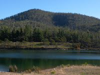
I had grown tired of the dank damp chill of the foggy Huon Valley, and hoped that the improved weather forecast for this morning would rectify it. However, it was pretty much the same as the last few days, although I did see a shred of blue sky above at one point quite early. Anyway, I wanted somewhere a little drier, so I headed for Risdon Brook Dam, intending to climb Mt Direction and then head northeast-ish to see if I could find the top of Gunners Quoin. More on that latter attempt later.

Forest along the track up Mt Direction - 29th July 2008Mt Direction affords good views of, amongst other things, the Derwent, Hobart's northern suburbs and Mt Wellington. The walk starts at the Risdon Brook Dam carpark, and heads across the dam and then around the impoundment to the first hairpin bend, where you head off towards Mt Direction. You quickly join a track that rises (and occasionally falls) fairly gently as it winds across the lower slopes. After around 10 minutes on this track, you reach an intersection with another track that heads steeply uphill to the left. This is the start of the main climb. This track just climbs and winds to the top. It's quite steep, and does go on for a while, but the forest is open and there's plenty of birdlife. The summit is marked by a large cairn, and there is a radio facility nearby.


Notherly view up the Derwent River, with Mt Dromedary at left - 29th July 2008You have to move around a little on and near the summit to get the best views. There's a little plateau to the west which gives reasonable views of Hobart and Mt Wellington. The views up the Derwent from the summit are quite spectacular. I recall being on the summit here in the 1970s (I was very, very young, you understand...) and being able to hear the cars clattering across the Bailey Bridge which was visible very steeply below. The Bowen Bridge is clearly visible these days when you get into the right position.


Gunners Quoin, above and right of centre, from Mt Direction - 29th July 2008After this I intended to head for Gunners Quoin, to the northeast of Mt Direction. There are tracks nearly to the summit marked on the maps. The track starts close to the top end of Risdon Brook Dam, and winds around the hills, mainly rising steadily, sometimes steeply, and occasionally falling gently for a way.


Track to Gunners Quoin enters private property - 29th July 2008I had every expectation of meeting a "Private Property, Keep Out" sign at some point, and eventually I did just as I was getting close. I am aware that the landowners around this area have trouble with motorcyclists and rock climbers who don't ask permission, so I turned around when I found the sign. Actually the walk was quite pleasant, the forest was open and airy, and when the sun came out it was a very enjoyable walk back.


Grasstree, Xanthorrhoea australis, upper Risdon Brook valley - 29th July 2008There are Grasstrees in groups along this track. I only found one with a flower spike. The flowering is apparently promoted by fire. I'm fairly sure these are Xanthorrhoea australis - there are three species present in Tasmania, plus hybrids. I've certainly seen the X. australis at Rocky Cape. The Wikipedia page and photos aren't instantly useful. However, this recovery plan for the other Xanthorrhoea species present in Tasmania is clear that Grasstrees near Hobart are X. australis. This site is of course also close to Grasstree Hill.


View Larger Map

Monday 28 July 2008

North West Bay River Fungi - 28th July 2008 (2)

Ramaria sp.


Leotia lubrica. These ones were more yellow than the ones I've seen before.


North West Bay River Fungi - 28th July 2008 (1)

It was raining on and off today and wasn't looking good for any walks much above sea level, but this afternoon it cleared a bit - or at least there were some periods when it wasn't raining, or not a lot...Found some new fungi.


I think this is Lycoperdon pyriforme


Geastrum triplex I think.

Saturday 26 July 2008

Hartz Panorama

I stitched this panorama of the Hartz Range from the plateau. Hartz Peak is the largest just right of centre, with Mt Snowy prominent at left. Adamsons Peak is in the distance at the far left. Bit difficult to see Adamsons at this web-friendly resolution. It was a very good day at the Hartz.

Hartz Range, Southern Tasmania - 24th July 2008

Friday 25 July 2008

Ferntree Fungi - 25th July 2008

Had a short walk today around Ferntree, finding fungi. I've got a new macro lens which, once I sort out the depth-of-field issues, will hopefully allow me to capture much better shots of the smaller fungi. There are a couple here that are attractive, but I need to play a bit with the focus and aperture to maximise the depth of field.


Thursday 24 July 2008

Hartz Plateau - 24th July 2008

Hartz Peak from Ladies Tarn - 24th July 2008I set off on a speculative trip to the Hartz today. Mt Wellington was pretty good yesterday, so I thought I'd see what the Hartz was like. Well, they don't clear the road as diligently as they clear the road to the Mt Wellington pinnacle. However, there are far fewer people, and the scenery is better, so there! I found myself pining for my dead Landcruiser. I chose the Liberty today, and it did OK, but I wasn't as free to choose my route or parking as I would have been in the 'Cruiser, or even in the nice new Forester!

Boulder with ice-floatie, Ladies Tarn, Hartz Mts - 24th July 2008The ranger was there sorting things out, and it was a marvellous day. The sun was warm on the skin, and I may have actually got slightly sunburnt! In the end I parked at the Arve Falls parking area and walked from there. Managed to walk the plateau. The walking was very pretty today, if a little more taxing than it usually is. Once beyond the visitor shelter, the snow was quite deep in places, particularly just next to the boardwalk. Compared to a normal walk here, it was very heavy going. I must investigate snow shoes.


Wombat tracks show the way beyond the Lake Esperance turnoffSome people were walking in front of me, so I followed their tracks. I met them up the hill a bit, but they had only gone to Lake Esperance. Fortunately, a wombat had also been to the lake, and knew the walking track ahead very well. I followed his tracks for a while, until they wandered off into the scrub. The wildlife obviously use the walking tracks as a highway. A bit further along a wallaby had used the track, covered by a foot of snow, for several hundred metres. In fact between Lake Esperance and Ladies Tarn the going was quite good. In general, the snow isn't too deep. There were some lovely views from Ladies Tarn of the snow-covered range, and the partially-frozen tarn was very attractive. Having to be home around 4pm, I had to curtail my perambulations there, although in truth I wasn't very well equipped for trying to climb Hartz Peak across deep banks of snow, so the time limit was quite acceptable.


Nevada Peak and Snowy South from Hartz Plateau - 24th July 2008Overall, it was a very enjoyable walk, but the floundering and falls in the snow were somewhat galling at times. My lack of coordination and balance in low-friction environments is quite obvious, and would have been amusing today if anyone was watching. I would have liked to see the various ranges around about from the summit, but I didn't have enough time. Progress was quite slow in the snow today. This view of Nevada Peak (L) and Snowy South (R) from the plateau was quite impressive though.

Wednesday 23 July 2008

Mt Wellington - 23rd July 2008

Looking towards the South Summit from the top of the ZigZag Track, Mt Wellington - 23rd July 2008Had a very enjoyable walk in the snow today. Stared at The Springs and walked to the top of Mt Wellington via the Pinnacle and ZigZag Tracks. There was snow underfoot most of the way, but it was only difficult in a couple of spots part way up the ZigZag. I wasn't too keen on how I was going to get down - my lack of balance on low-friction surfaces is pronounced. Anyway, as I was going up, I realised that as the road was closed at The Springs, then a walk down the road would be quite pleasant. At that point the snow underfoot became thicker, softer, scrunchier and "sticky" so the climbing got easier.

View to Hobart from near the summit, Mt Wellington - 23rd July 2008There were reasonable views for much of the time, but some cloud was hanging around the summit. When I got to the summit, I had it to myself, no cars, no people. very quiet. I had lunch in the visitor shelter, on my own. As I left, and walked down the road, a Tas Government car came up the hill. It was soon followed by others, but not huge numbers. The walk down the road back to The Springs was certainly easier than slipping and sliding back down the ZigZags. All in all, a very enjoyable walk.


Kerosene Bush, Ozothamnus ledifolius, Mt Wellington - 23rd July 2008Tasmanian alpine plants are very well adapted to not just the cold, but being regularly covered with snow, uncovered, soaked in freezing rain, frozen again, and being blown around almost incessantly. Compared to mainland alpine areas, Tasmanian alpine zones don't have reliable deep snow cover for the winter. It tends to come and go. as a result, the plants in these places are extremely hardy and put up with a lot of abuse from the elements. This is the Kerosene Bush, Ozothamnus ledifolius, (previously Helichrysum ledifolium). The horizontal icicles formed on these plants show just what they have to put up with. This is an endemic Tasmanian plant and dominates the alpine heath on Mt Wellington. It is also known as the Hepatitis Daisy-Bush. Nice! This comes from the yellow substance exuded by the leaves which gives the plant its characteristic colour.


Thark Ridge from Mt Wellington - 23rd July 2008Just to be pernickity. Since they installed it, the diagram of the hills visible to the east and north-east has contained a significant error. Check out the photo of the detail in question. A lump on the left-hand side is labelled as Mt Maria. It isn't, I'm fairly sure it's Mt Freycinet. Whatever it is, it is not Mt Maria. Maria Island can be seen in the distance on the right-hand side, below the words "Midway Point". It's a fairly stylised approximation of the shape of Maria Island, but I think the high point towards the right of the island shape (south) is actually Mt Maria. And don't get me started on the various dates and numbers of years given in the information about the building of the Tasman Bridge.


Erroneous marker for Mt Maria, Mt Wellington visitor shelter - 23rd July 2008Finally, this view looking towards Thark Ridge made it clear just what a cold and stark place the back of the Wellington Range can be in winter weather.

Tuesday 22 July 2008

South Cape Bay Track Fungi

Of course!!


Probably Russula persanguinea.


Looks like Clavaria amoena.

Little Penguin (Eudyptula minor)

Along the rocks today I came across this Little Penguin (Eudyptula minor). He struggled out of my way, and I caught sight of him moving out of the corner of my eye. I realised he was either ill or injured. He propped himself on a pebble sitting next to a large flat boulder, and just sat there shivering and shaking, with laboured breathing. He wasn't very happy about me being there, but he wasn't moving.

When I came back along the beach about 45 minutes later, he was in the same spot, hadn't moved. The crows had spotted him, and had flown/sat around him a bit. He grumbled at me very slightly, but didn't appear to have the energy to do anything. I have no idea what was wrong with him, nor whether you can pack up penguins and "save" them. If I found a baby wombat, I know that if it was large enough you could save it, but I thought any attempt to save this little fellow would probably be abortive. Apart from anything, he was quite unhappy with my presence, and I suspect he'd have just carked if I'd picked him up.

South Cape Bay - 22nd July 2008

South East Cape from the cliffs above South Cape Bay - 22nd July 2008Had a very good walk to South Cape Bay today. The forecast for Wednesday is "fine"(ish) so I thought I should walk close to sea-level today and find the snow tomorrow when the weather might be better. It rained a bit today, sometimes heavily, often just drizzling, but there were also lengthy fine and even sunny breaks.

lion Rock from the cliffs above South Cape Bay, showing the black shaly ?coal of the cliffs - 22nd July 2008The sea was quite rough, but I'd expected it to be spectacular. I really do need to go down there when they've forecast a full storm one day. Last time they did that, I couldn't. Today they forecast 4m swell and 4-6m seas. I've seen them forecasting 8m swells and 6m seas before. The Cape Sorell Waverider Buoy shows just how big waves can get off the west coast.


Oystercatchers and Lion Rock, South Cape Bay - 22nd July 2008There were a lot of Oystercatchers on the beach today. I'm always interested to see how the Pied Oystercatchers (Haemotopus longirostris) hang out with the Sooty ones (H. fuliginosis). Here's five Sootys and a single Pied (left). I've seen this before here. I think this Pied was the only one on the beach. I've seen them together often here. Maybe he doesn't know he's not a Sooty Oystercatcher? Makes you wonder if they're actually separate species.


Bluebottle (Physalia utriculus), South Cape Bay beach - 22nd July 2008The weather today made for interesting light, which improved the photos compared to a solidly grey day. However, it was very difficult keeping the rain and salt spray away from the camera lens. Overall, very enjoyable. The weather can't have been too rough, as the beach is still in place. When there's really rough weather, the beach generally moves quite significantly. However, there were quite a lot of small items of flotsam cast quite high on the beach. Among them were a number of Bluebottles (Physalia utriculus). These had just been left by the tide when I came upon them, and were quite fresh and reactive.

Monday 21 July 2008

Ridgeway Tracks - 21st July 2008

Ridgeway Reservoir dam wall - 21st July 2008The weather today in Tasmania was pretty ordinary, but I did need to get out. Too many sick people at home! I had been eyeing off the various tracks around Ridgeway, and given the weather, it seemed like a good day to do some exploring lower down. I parked at the entrance to the Ridgeway Reservoir. You can walk along the firetrail and then head downhill (on the No-Through track) to come out next to the eastern end of the dam wall. The dam really is pretty large. You can obviously climb down to the base of the dam, which I didn't do today. I understand you can get a good echo from the dam wall too. This might be a place to take the kids for some entertainment one afternoon.

Heading back uphill to the main firetrail, I next walked out to near the Southern Outlet. The Council have closed the track here for some reason. I think it would be somewhat unsafe trying to cross the highway anyway, so I turned back. Interestingly, there are a lot more tracks than are shown on the map (Taroona 1:25,000). I find this quite strange, as the map is a 2005 edition. Not sure why they leave some of these tracks off, and I'm talking about the main, named and signposted firetrails here.

From there I walked approximately northwards to an intersection of quite a number of tracks. A track heads quite steeply uphill onto Tolmans Hill, past a reservoir, and then downhill to Woodridge Place in the suburb of Tolmans Hill. You could probably park here as a starting point for a walk. Retracing my tracks, I then used an unmarked but obviously long standing firetrail to return to the car at the reservoir entrance.


The sun comes out, Ridgeway - 21st July 2008From here, another track heads uphill across the road. There are more tracks here which are not marked on the map. I climbed to the top of this hill, where the sun came out! I spent quite a while here trying to get photos in the brief periods where the sun came out from behind the clouds. There is also supposed to be a cave up here, Sixpence Cave. It's marked on the map, as "posn approx". I couldn't find it anyway. I'll have to go back and try again sometime. This track continues on, crossing Chimney Pot Hill Road, and joining a track up Chimney Pot Hill. From there you can walk on to Halls Saddle.


Mt Wellington from Ridgeway - 21st July 2008Anyway, the forest is fairly open across most of this area, and the walking is quite pleasant, even on a day as wild as today. I had rain, sleet, snow, hail, wind and occasional sun. On a day when the weather is better, it would be good to climb Mt Wellington starting at Tolmans Hill. Charles Darwin apparently used these hills to access the mountain when he climbed it in 1836. I believe the Hobart Walking Club sometimes retrace his approximate route in a "Darwin" walk.


View Larger Map