


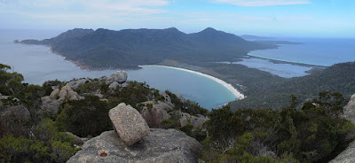
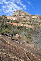
 After a nice easy Saturday, a slightly more strenuous walk was indicated, so I headed up Mount Amos. This walk departs from the same carpark as the Wineglass Bay walk. The signs warn that the walk is across sloping rock and can be hazardous when wet. After the recent rain, there were more damp areas than usual, but it wasn't too bad. I think it would be very difficult if it was raining and the rock was generally wet underfoot. There are spots where the dry rock is very slippery. Interestingly, some of the wet patches are obviously where the water "normal" flows, and most of these were perfectly grippy, as the softer minerals have been eroded, leaving the protruding quartz crystals to provide a bumpy surface.
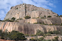 Views from the summit are really impressive, and as long as you can handle the steep rocky bits, the walk is not too hard. I did meet a bloke who had got himself half way up the central gully, but was obviously unhappy on the sloping rock and chose to walk back down rather than risk a fall. His expensive-looking shoes may not have been as grippy as he had hoped. The granite is what makes the Hazards such an impressive sight, and many great photo opportunities present. The climb up Mount Amos makes evident (see photo) this interesting intrusion of a grey granite into the more dominant pink granite.
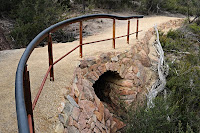 In search of a part of Tasmania where it was raining less frequently, I headed to Coles Bay, and on the Saturday had a pleasant and quite easy walk over to Wineglass Bay. The first part of this walk appears to receive the majority of National Park funding in Tasmania, and the engineering marvels along the track are quite spectacular. I gather the place is absolutely chocka in summer, which is probably a good reason to stay away. The track to the saddle has been built almost to wheelchair standards - in fact I don't doubt that the first part could be so used. The edges are all lined with extensive retaining walls, and the bridges such as this one have been built lovingly. This, and other, bridges appear to be built with drystone arches, which are really quite interesting. I didn't duck my head inside them to see whether some other structural arrangement is disguised, but at least externally they are quite impressive. The track is now formally a circuit below the final ("staircased") climb to the saddle. There is an outward track and a return track. The return track appears closely (or exactly) aligned to the older track route. The walk is still pleasant.
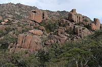 The weathered granite remains intriguing. Those who did this walk before the advent of the viewing platform near the saddle will recall clambering around and onto these outcrops to the right of the saddle in order to get a view to the south.
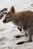 The wallabies remain ubiquitous, and despite the signs forbidding their feeding, obviously still hold out hopes of treats from walkers. This one was going from person to person on Wineglass Bay Beach.
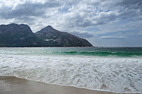 The view of the steeply sloping granite falling from the Hazards into Wineglass Bay remains spectacular. This is particularly so under certain light conditions, which I didn't really get this day. Dolphins and seals were frolicking in the bay, and made for some extra interest, but were not quite as unusual as the Southern Right Whales seen there last year.
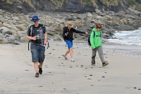 It was school holidays, and The Swarm (of locusts) needed to be taken out and made to walk as an antidote to the various electronic games with which they had "wasted" much of the rest of their holiday. South Cape Bay is a good lengthy walk without taxing hills, and not too bad even when the weather higher up is a bit iffy. The trip was akin to what I imagine a walk with Hobbits would be like. It commenced with a large breakfast (probably half a big box of Nutri-Grain each, they're cheaper by the pallet), and then a ritual emptying of the fridge and cupboards into backpacks. After an arduous 40 minutes by car, they required refuelling at Dover with second breakfast, so egg and bacon rolls were purchased and consumed before they succumbed to impending hunger. I felt I had to join them in this ritual, so as not to make them feel in any way guilty about the cost. Having eaten all the Dover Takeaway's E&B rolls (The Swarm has been there!) we resumed our journey.
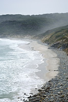 A quick snack (elevenses?) further fortified them for the walk on arrival at Recherche Bay, and occasional devouring of muesli bars and chocolate continued to lighten packs as the walk proceeded. They were obviously well fed, as the leaches found their ankles enticing. First lunch was taken on the cliffs overlooking South Cape Bay, before a stroll along the beach produced a need to eat again (second lunch?) at the western end. Supplies were running low, allowing only a few snacks on the return journey for The Swarm. Blood glucose was dangerously low on return to the car (that is, there was a little too much blood in their glucose stream). Valiantly I drove them in an emergency dash to the Dover Grocery Store, where enormous fudgy ice creams provided sufficient energy to enable them to snooze comfortably (and me to drive) for the 40 minutes return drive home. This was the land of milk and honey, or at least milk, Weet-Bix and Milo, which can be taken in equal quantities (large ones) in a full large soup-bowl, as I have discovered. This, and occasional glasses of milk, tided them over until dinner, as I recall. Anyway, they seem to be as slim as ever, so I'm worried that maybe I underfed them...

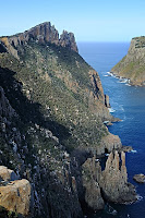 So, to finish off the Three Capes, it was off to Cape Pillar for an overnighter. This walk is often done as a three-day walk, which allows a day to walk in, a full day to explore the cape and a day to walk out. I decided I could do it in two, and although it made for a longish day of walking on the first day, this is quite achievable. I'm not supremely fit, and the heaviest thing I've been used to carrying lately is my stomach, so minimising the weight by minimising the food to be carried was welcome. If I did it again, I'd probably go for three days, but in fact, the walk in to the campsite isn't long enough for a full-day's walk, and you will probably want to supplement it with a brief excursion further along the cape - the views are superb and will occupy you for hours if you wish.
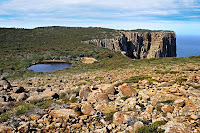 So the usual walk would be Day 1 - Walk to Perdition Ponds (or other campsite); Day 2- Explore the cape, which can take between 4 and 8 hours; Day 3 - Walk back out. Other campsites include Lunchtime Creek, Bald Hill. Some people apparently camp at the very end of the cape, Chasm Camp, where there is supposed to be a "soak" providing water. Good luck if you choose this. "The Oasis" was wet when I was there, and is a little further along than Perdition Ponds, but it wasn't "flowing", and was rather more a sequence of muddy puddles and damp patches. The water in Perdition Ponds was OK, despite the ranger's advice to me, and tasted perhaps a little better than Coles Bay water at a bad moment. Lunchtime Creek water is noticeably nicer however. The water at Perdition Ponds acquires some mineral salts taste from the surrounds. I think it could become quite "tasty" in dry weather.
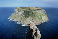 The "new" track has been in place for some years now, and leaves from Fortescue Bay, maybe 100m back up the road from the ranger station. It is very well made and climbs gently around the hill and across a few small gullies, emerging on the flatter hilltop after a surprisingly easy climb. The track then undulates a little, climbing around Tornado Ridge and descending steeply to Lunchtime Creek. There's a phytophthera washing station here. Climbing begins again after Lunchtime Creek, but not greatly, and after crossing Hurricane Heath, the track comes out above Perdition Ponds, and cliff vistas start to be visible. The good campsite at Perdition Ponds is located very close to the 300m cliffs, although the scrub is quite thick, so sleepwalkers would have to navigate effectively to find their way into trouble...
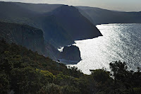 At this point I dumped the pack and walked on with light gear and the camera. Beyond Perdition Ponds it is only a few minutes before you start to get superb, even stupendous, views. The track undulates along the cliff edges, providing new views every few minutes. The track is quite rough in places, and it does take longer to navigate than the quite small crow-flies distance would suggest. Not least, this is because you will be stopping every few minutes to gingerly approach the cliff edge and be gobsmacked at the view. The Blade is not to be missed, and provides a supremely spectacular view of the surrounding cliffs and Tasman Island. Beyond The Blade, there are further lookouts. I suspect I didn't find the last one - Chasm Lookout - as I didn't get the view of Cathedral Rock I discovered I should have had when I read the guidebook after my return(!) I'll have to go again to find that final lookout. Anyway, it's all very spectacular, and easily worth the effort of the walk.
View Cape Pillar in a larger map
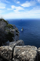 To continue my Three-Capes extravaganza, I next set out for Cape Hauy, just as a daywalk. I should walk over Mount Fortescue one day and join the Cape Hauy walk to the Cape Pillar walk, as I hear the views are very good. It's just I'm not entirely reconciled to carrying a full pack over a 490m mountain when you can walk around the side of it.... Note that in common with most Tasman Peninsula coastal walks, there are a lot of unprotected cliff edges at which you can arrive suddenly, take care and keep the kids under control.
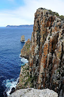 Anyway, Cape Hauy is spectacular on its own account, featuring the Candlestick and Totem Pole, features of great rock-climbing, and scenic, interest. There are also great views up and down the coast, and especially of Cape Pillar. This walk starts from Fortescue Bay, where the ranger is diligent in checking vehicles for parks passes - best to make sure yours is visible. The walk heads along the coast past the boat ramp at first, then turns inland and uphill. It climbs steadily over a moderate hill to emerge at the top of a steep hill looking seawards along the length of the Cape. This whole area was burnt a few years ago, and the effects are still evident although improved. The walk descends and rises a couple more times, before the track emerges on the spectacular platform at the end of the cape, overlooking the Candlestick. Best views of the Candlestick are obtained by descending very steeply (and carefully) towards sea level at the end of the cape. More information here and linked from here.
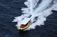 Of interest while I was there was the voyage of the Tasman Island Cruises boat. This is operated by Rob Pennicott, with whom I went to school, and is well known as an exciting trip. I must do it myself one day - looked exciting as I watched them sailing about in the quite rough seas. Tasman Island Cruises were kind enough to give my oldest son so-called "work-experience" recently, so they deserve a big plug. I say it was so-called, because for four of the five days he basically tooled around in a very powerful boat looking at Tasmanian scenery. One of his texts, when he was yet to get on the boat, said "if this is work, bring it on". However he did learn to be nice to tourists, day after day, and got some valuable experience of driving a large boat in rough seas under close supervision. Thanks to Rob and staff.
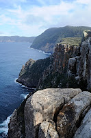 Not-to-be-missed on this walk is the sidetrip to Monument Lookout. Near the top of the hill on the return walk a track heads south to Monument Lookout and Mount Fortescue. About ten minutes along here the track emerges at the very high and spectacular lookout. This is rather precipitous, and great care is required, but the views are impressive, and just the sheer height above the water makes this worth a visit. The "Monument" is the significant sea-stack lying just south of Cape Hauy. I've got a shaky recollection of some material about it being climbed - I think involving Peter McHugh and Mendelt Tillema, which I must find - it seems it may be on this website somewhere, but I can't get thesarvo to download right now.
View Cape Hauy in a larger map
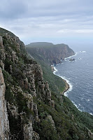 Cape Raoul is the south-western extremity of the Tasman Peninsula, a sort-of companion-cape to Cape Pillar, which is the south-eastern point. Unlike Pillar, Raoul does not require an overnighter. (Having said that, I know some people do Pillar as a day-walk, but it's a very long day and probably only achievable in summer without running.) The walk to Cape Raoul is around 5 hours allowing some viewing time. The walk starts at Stormlea, accessed by heading from Port Arthur towards Nubeena, then turning left (south) at the signposted road and following the signs to then end. Cars need to be parked where indicated, and not blocking roads or gates.
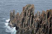 The track crosses private land at first and appropriate respect would be useful in ensuring the continuation of this access. The walk heads uphill first, and after about half an hour emerges on top of cliffs which are 400m above the sea. Just prior to this, the track passes a junction where truning right leads steeply down to Shpistern Bluff and Tunnel Bay, another worthwhile walk. The views from here are pretty impressive, both of Cape Raoul and back towards Shipstern Bluff, South Arm, Betsey Island and many other places. The track then climbs a little further before descending significantly through attractive mossy forest onto the Cape. Further views are obtained in places as the track winds along the western cliffs towards the end. At the far end, visitors should make sure they go to the end of both tracks to obtain all the views available. Particularly, the seal colony is visible from the end of the left fork (to the east). The seal colony is visible in the photo, and is on the light-coloured patch to the left of the extremity of the cape. If you don't know where to look, the height of the cliffs, and distance, make the seals somewhat insignificant and hard to spot. The dolerite columns at the end of the cape were used for target practice by the British Navy during World War I, and as a result it is a little more ragged than it would otherwise be.
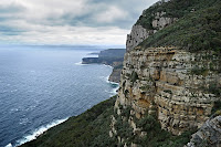 It is important to note that this walk features stupendous cliffs, and none of them have the slightest fall protection, making them instantly fatal in case of a fall. It is important to very closely supervise children at all times, unless you are confident in their common sense. At times, high winds can make the cliffs more dangerous. Signs erected by Parks & Wildlife make it clear that your safety is your own responsibility in this area.
Cape Raoul is the first cape on the government's planned $20M "Three-Capes Walk", which will then take in Hauy and Pillar after using a boat to cross Port Arthur. I'm not sure what to make of this proposal, as many of the tracks around here were cut and maintained by volunteers over many decades, and the government's plan now appears likely to change and limit the access to and use of those tracks by Tasmanians just wanting to enjoy their national parks. No doubt it would be a good money-spinner, but I'm not sure the people who will come and walk it will be getting any sort of authentic experience - once we spend $20M to make our Three Capes attractive to tourists, is it really the Tasmanian bushwalking experience?
View Cape Raoul in a larger map