Wednesday 30 January 2008

Pipeline Track - 30 January 2008 - Ferntree Bower

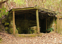
Shelter at the Ferntree Bower - 30th January 2008Another quick walk after work tonight to forget about salary budgets. Walked along the Pipeline Track again for a way. Apparently the Ferntree Bower used to be a great beauty spot where people "promenaded". It's a little more modest these days. The nearby sign tells the story:

"When this part of Browns River became known as the Bower (later Fern Tree Bower) in the 1860s, the scene was very different from what it is today. A dam built across the river in 1862 made a pond, around which grew overhanging tree ferns. It bacame the Mountain's most famous beauty spot. people walked (or promenaded) along the track following the water line from the saddle at Fern Tree Inn to the Bower, where they could enjoy a leisurely picnic or a walk upstream to Silver Falls before heading home. Over time, rustic benches, tables and shelters were installed. In 1880 the Bower was the subject of controversy when the Hobart City Council removed trees to allow work to be done on new masonry troughing. The Council pointed out that the Bower was first and foremost a water collection point, but did take steps to lessen the visual impact of the tree removal.

Fern Tree Bower, inscribed stones salvaged from the original water tower, see plaque below - 30th January 2008

…the sluice house and dam, along with picnic facilities and most of the natural fernery, disappeared in a devastating flash flood in 1960.

From Hobart City Council sign. The Pipeline Interpretation Project. An initiative of the Fern Tree Community Association, supported by the Hobart City Council. Original research by Lindy Scripps.


FERN TREE BOWER - These inscribed stones were salvaged from the original water tower erected in 1861 and destroyed by the Great Flood of 23rd April 1960. This tablet is erected by the Hobart City Council to commemorate its rehabilitation in 1961. - 30th January 2008Plaque at

"FERN TREE BOWER
These inscribed stones were salvaged from the original water tower erected in 1861 and destroyed by the Great Flood of 23rd April 1960. This tablet is erected by the Hobart City Council to commemorate its rehabilitation in 1961."
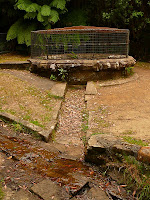

The Wishing Well, Pipeline Track, Mt Wellington - 30th January 2008This is a better picture of the "Wishing Well" a little further along the Pipeline Track.
Tuesday 29 January 2008

Pipeline Track - 29 January 2008 - The Sluice House

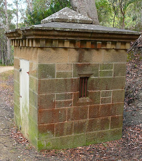
Sluice House, Pipeline Track, Mt Wellington - 29 January 2008Good short walk this evening along the Pipeline Track on the way home from work. The Sluice House stands just below the intersection of the Pipeline Track with Chimney Pot Hill Rd. This text appears on the nearby sign to explain it.

"This little building, known also as the "Valve House", was built in 1862 by mason John Gillon, who also built the receiving house and valve tower at the lower reservoir and dams at Browns River and Fork Creek. The cost of the whole construction was £63/7/- ($126.70 in modern currency). The hammer-dressed sandstone probably came from the outcrops at Gentle Annie Falls. The building contained a sluice gate made by the City Corporation, located directly above the original pipeline. The sluice could be raised or lowered to control flow through the pipe, allowing water to be diverted down the hillside to Sandy Bay Rivulet when work was required on the water line below this level. The diversion caused soil erosion because of the lack of a lined channel for the diverted water, though there is little sign of this now. At one point C.W. Hall, the owner of land below the sluice house, applied for compensation for soil loss, but failed on the basis that his steep, rocky land was unsuitable for cultivation.


From Hobart City Council sign. The Pipeline Interpretation Project. An initiative of the Fern Tree Community Association, supported by the Hobart City Council. Original research by Lindy Scripps.

Dressed stone covering the pipeline, Pipeline Track, Mt Wellington - 29 January 2008The dressed stone which originally covered and housed the pipeline is visible in many places along the track.


Gentle Annie Falls, Pipeline Track, Mt Wellington - 29 January 2008Gentle Annie Falls drops away steeply down the hill to the Waterworks. It's a long time since water actually flowed down here.

Monday 28 January 2008

South Cape Bay - 28th January 2008

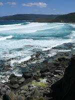
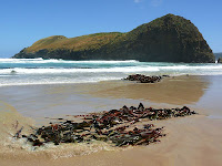
South Cape Bay and Lion Rock - 28th January 2008Very good walk today to South Cape Bay. (Map here.) The track was quite busy, with many day walkers and also a number of people who seemed to be finishing the South Coast Track. Most of the latter were quite cheerful. It was a warm day, reaching 28°C in Hobart. I think it was a little cooler than that down south, but Blowhole valley was fairly warm on the return. The beach was great, with a gentle surf and a cool breeze.


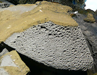
Weathered boulder, South Cape Bay - 28th January 2008The cliffs at South Cape Bay are weathered in a wide variety of ways. The cliffs themselves are shaly coal-like rock, with columns and boulders collapsing into the sea. This boulder sits below the cliffs just where the track arrives at the coast. It is among several with this mottled, honeycombed weathering. I'm thinking this is caused by salt water weathering this particular type of rock, but will stand corrected.


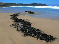
Kelp and Lion Rock, South Cape Bay - 28th January 2008There was a lot of giant kelp lying on the beach, stretched out and piled up. I'm assuming this kelp is Macrocystis pyrifera.


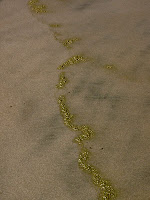
Green scum, South Cape Bay - 28th January 2008There was a green scum in the foam, which deposited on the sand as the waves crept up the beach. I think it was an algae, but I'm unsure. Hope it isn't poisonous because I had a nice paddle all the way up the beach and back today.


South East Cape from South Cape Bay - 28th January 2008I gather there is now a track to South East Cape, cut illegally. Some day I will try to find the start of it, the location of which has been described to me, but which only appears to be accessible when the tide is right. I think you'd want to make sure you had time to get back, or were willing to wait through a whole tide. South East Cape was apparently previously reached by climbing Bald Hill from Blowhole Valley, then scrub bashing for some hours along the hills to the cape. Didn't sound much fun, so if there's a track now, then it might make for a worthwhile trip.

Dragonfly

Dragonfly, Russell Falls, Mt Field National Park - 26 Jan 2008Spotted this dragonfly, resting at Russell Falls the other day.

Monday 14 January 2008

Oh, and Erica strikes again

The Letters page today in the Mercury featured a letter from Pete Roberts responding to Erica Betts' (and isn't that link just so beautifully out of date) letter last Wednesday, 9th January. Erica continues to imply that the main aim of logging in Tasmania is to supply sawn timber. This is deceitful and ignorant. As I showed last year, Erica thinks woodchips are made from the little bits that result from turning round logs into square boards, and he even immortalised his ignorance by writing to The Age. They've kindly preserved a copy of his letter online...Mmmm, makes you wonder how he can walk and breathe at the same time really.

Mining at Cox Bight??

I got this in my email from an anonymous correspondent, with a bit more info than was on the TV the other day (I think it was TV). Bit of an issue though, the thought of a new tin mine being established at Cox Bight - slap in the middle of Tasmania's South West WHA - is like some weird joke anachronism. As the correspondent points out, the government does appear to have moved quite sneakily on this.


-----------HERE IS YOUR LETTER FROM AN ANONYMOUS SENDER-----------

Dear friend,

You've received this e-mail because you are a friend of Tasmania's South-West wilderness, particularly the famous and beautiful South Coast track.The Tasmanian government is planning to allow a mining company to explore for tin along a 15 kilometre section of the track. The 35-square kilometre area stretches from Melaleuca to Cox Bight. The exploration could include helicopter-supported drilling in what is a critical habitat for the endangered Orange Bellied Parrot. The exploration will bring maybe $80,000 worth of investment to the state. If mining were to proceed it would impact severely on the World Heritage area and would be visible from many areas of the track and beyond.Cynically, the Tasmanian government announced its plan on the Sunday before Christmas, in the last lines of a press release issued at 6pm. Make up your own mind - read the Tasmanian government press release here.

http://www.media.tas.gov.au/release.php?id=22789

The approval process is being handed by the Tasmanian Minerals Council. Details of the proposal are somewhere on their website, but good luck finding them. Objections close in a few days. It will cost you $25 to lodge an objection.

http://www.mrt.tas.gov.au/

The Tasmanian National Parks Association is opposed to the plan. They say mining leases in the area should be cancelled as mining ceases. So too does the the WHA's management plan. The area should have been included in the WHA in the first place.

http://www.tnpa.asn.au/

http://www.parks.tas.gov.au/wha/managem/managem.html

Paula Wreidt is Tasmania's tourism, arts and environment minister and is responsible for national parks in the state. If you're opposed to mining inside the World Heritage Area, let Paula know.

paula.wriedt@parliament.tas.gov.au

If plans to consider mining inside a national park will affect your plans to visit Tasmania or the South Coast Track, let Paula know that to. Tell her how it might change your plans and how much you would have spend. Tell how many friends you've sent - or would take with you.

Tasmania's wilderness is worth far more than a few thousand tonnes of tin.Pass this message on to anyone you know who has walked or who loves the South Coast Track, or is a friend of the south-western Tasmanian wilderness and urge them to act too ... let Paula know.

Sunday 13 January 2008

More Hartz Mountains Flora

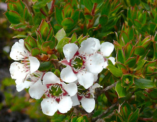
Leptospermum lanigerum, Woolly Tea-tree, Hartz Mountains - 12th January 2008Leptospermum lanigerum, Woolly Tea-tree. Photographed on Hartz Plateau 12th January 2008. The area where I took this picture has a lot of water flow amongst the scrub. This plant is described as "Common, widespread in damp places, river banks, montane grasslands and rainforests of west coast where it may become a tree to 18m." (A Guide to Flowers and Plants of Tasmania, Launceston Field Naturalists Club.)
References: ASGAP, ANBG, Uni of Tas, Google Search.


Melaleuca squamea, the Swamp Melaleuca. Photographed on Hartz Plateau 12th January 2008. There are a lot of these plants along the first part of the track, mostly quite small shrubs. They are apparently widespread in wet heathland between sea level and 1500m, which seems quite a range. They range in flower colour at Hartz from pink-purple through to cream and white.
References: Uni of Tas, CHAH, Google Search.

Saturday 12 January 2008

Hartz Peak - 12 January 2008

Mt Picton across Hartz Lake from the Hartz Peak track - 12 January 2008Good walk today to Hartz Peak. (Map here.) Sunny and warm, with a few bushfires around, but the Hartz didn't seem smoke-affected. You could certainly see the fire burning in the Arthur Range, and there was a dense pall lying across the Huon Valley and obscuring the Wellington Range, but the Hartz themselves were clear, with cool breezes high up requiring jackets for most people. Quite a lot of walkers on the track, including many tourists.


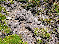
Curly, dried purple mud, Hartz Mountains - 12 January 2008It did seem to be very dry. I'll have to find the long term rainfall averages. There's been almost none this month, but there was over 100mm last month. Certainly some pools that normally have water in them are dry. I noted this curly dried mud. It had a strange purplish-cast to it, and seemed to be a thin layer of a different material laid across the top of the other mud. Then it's all dried out, cracked up and curled. Bit strange anyway.


Mountain Rocket, Bellendena montana - 12 January 2008There are many wildflowers out, which certainly brightens up the appearance of the scrub. The Mountain Rocket (Bellendena montana - 'beautiful lady of the mountains', I think) is particularly noticeable and attractive. These spindly flowers will give way to the flattened, hanging bright-red (or yellow sometimes) fruits.


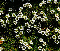
Cushion plant, Donatia novae-zelandiae - 12 January 2008The cushion plants are also attractive, with tiny white flowers scattered across their surface. This one is Donatia novae-zelandiae, the Western Cushion Plant, and is probably the commonest cushion plant in Tasmania. Apparently seedlings of many plants actually manage to grown in the tops of these plants.

Tuesday 8 January 2008

Pipeline Track - 8 Jan 2008 - Christmas Bushes and a Wishing Well

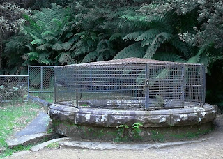
Wishing Well, Pipeline Track, Mt Wellington - 8 Jan 2008Had a very pleasant, short, easy, after-work walk along the Pipeline Track on the way home. Nice and cool under the trees. The Wishing Well, a little way along the track, was built in the 1880s, and is still part of the water system for Ferntree and Kingborough. I quote from the sign nearby:

"The original Mountain water supply scheme ended here at Fork Creek. In 1862 John Gillon (who also built sluice houses at Browns River and Halls Saddle), supervised construction of a stone dam across Fork Creek, from which water was carried by wooden troughing to another dam at Browns River (the Bower). The troughing was replaced by pipes in 1868, when the water supply scheme was extended to Long Creek, a few kilometres to the south.

In 1881 there was a major addition to the Hobart water supply with the construction of a line from St Crispins Well to the south, and this called for construction of the "Wishing Well", in which water from Fork Creek joined the bigger flow from Plains Rivulet. The 1868 pipes to the Bower were then replaced by a 16 inch (40 cm) main. The well was fitted with a "bell-mouthed pipe, wire gauze screen, shut-off sluice and scour", according to a newspaper report of the works.

The original well had no safety precautions, although no human casualties are recorded. Before intake screens were installed, platypus, which occur in Mt Wellington streams, were known to drown in the well. The eminently practical reasons for building this structure did not stop people from ascribing to it the power to make wishes come true. For this to happen, according to local folklore, you must walk around the well three times after making your wish.

Look after our water! Throughout the history of the Pipeline Track, successive authorities have been concerned to protect catchments to ensure sustainability of the public drinking water source. Water from this pipeline is the only source of supply for Fern Tree and is a significant source for the Kingborough community. Your cooperation and care in helping to protect this supply are appreciated."


The sign credits Lindy Scripps with the research, and was erected by the Hobart City Council at the initiative of the Fren Tree Community Association. There are quite a number of similar signs along these tracks which give a good overview of the history of the Pipeline Track, its structures and the history of Hobart's water supply.


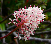
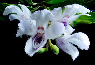
Christmas Bushes, Prostanthera lasianthos, Pipeline Track, Mt Wellington - 8 Jan 2008The Christmas Bushes, Prostanthera lasianthos, are quite appropriately in flower. The leaves have serrated edges and a minty scent when you crush them. The flowers are quite distinctive, being an attractive white and purple.

Sunday 6 January 2008

Lost World Panorama

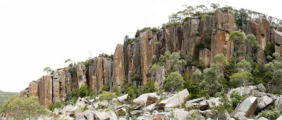
Stitched panorama of the cliff at Lost World, Mt Wellington - 5 Jan 2008
I took this as a series of three shots. It's hard to get a view of the whole cliff without trees getting in the way. This contains some distortions which the stitching software couldn't remove, but gives an idea of most of the width of the cliff. I'll see if I can get a better one another time. There may be a better spot to shoot from along the edge of the largest boulders, depending on access and the location of trees.

Saturday 5 January 2008

Lost World - 5 January 2008

Cliffs of Lost World - 5 Jan 2008Went to Lost World in November, and it rained. (Map here.) Couldn't even see the cliffs that day. Went again yesterday, and there were much better views, although it was very warm. The track is much easier to follow when there isn't a thick clag, and it's much more obvious exactly where you are. The last time I couldn't even tell where the cliffs were, so had no reference to suggest how far down the hill to walk before trying to head right into Lost World. When it's clear there are a number of good vantage points where you can look down and see both the cliffs and the jumble of boulders.

Cave beneath large boulders in the centre of Lost World - 5 Jan 2008I went for a wander, and found a lovely cool, deep cave, but couldn't see enough to continue exploring. Anyway, it was a nice relief from the heat. Obviously, you need to take a torch to explore beneath the boulders. Apparently there is a maze of tunnels beneath the boulders, and it is possible to get lost. It also looked like it was possible to falll down a hole which was deeper than you might have expected.


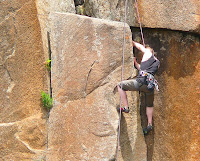
Climber at Lost World, possibly on 'Stone the Crows' - 5 Jan 2008There were some climbers having a go, which was interesting to watch. I'm trying to work out from the climbing guide which climb they were on. Could have been "Stone the Crows". There is a gully directly behind where they were climbing, which I think is the one the climbing guide says is "NOT recommended".


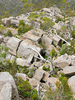
Fallen dolerite columns at Lost World - 5 Jan 2008The laid-down columns of dolerite here are really quite spectacular. They are quite chaotic, and when you get beneath them you can see how they are lying higgledy-piggledy across each other, leaving both gaping chasms and deep narrow slots. Some care is required in moving around, but it's not too difficult. There are a couple of quite large drops into black holes, partially obscured by vegetation. If you took children here, they might need to be watched.