Sunday, 17 August 2008

Chimney Pot Hill - 16th August 2008

Mt Wellington from Chimney Pot Hill - 16th August 2008There are plenty of tracks at Ridgeway, mostly well formed and marked. They aren't all on any single one of the available maps however. Parking at Halls Saddle is a good point to start an easy walk up Chimney Pot Hill. See the map for info. This hill provides a great view of Mt Wellington. At the top, next to the Telstra installation, there's an old rock hut, which looks like it was probably a store-hut for some original hilltop installation in years past. The Mt Wellington view is superb from here and well worth the climb.

Forest at Ridgeway - 16th August 2008Leaving the top, there are a range of options, and you can explore the tracks as time and your desire for hill climbs dictate. On days with dodgy weather, these tracks offer some good views without quite the altitude of the upper slopes of Mt Wellington. The forest is very open and attractive, and there are good views through the trees at many points.


As an aside, the nearby native plant nursery (Plants of Tasmania Nursery, 65 Hall St Ridgeway) has a great range of Tasmanian plants often seen only in their natural habitat, and is worth a look.


View Larger Map

Saturday, 16 August 2008

Fungi from the South Cape Bay Track

Fungi (hygrocybe?) on South Coast Track - 15th August 2008I think this one is a Hygrocybe, and very similar to one I found on a different part of the track in May 2007.

South Cape Bay - 15th August 2008

South Cape Bay - 15th August 2008With the Tasmanian winter continuing, it was time for a good sea-level walk. South Cape Bay would have been wilder, with bigger surf, a day or two before, but transport issues led to Friday working out. Despite having been recently, I headed off, hoping the weather was moderate. This is a really good walk, and I do enjoy the wild coast once you get out to the bay. The weather wasn't promising in the Huon on Friday morning, but as it turned out, I got quite a lot of sun mixed in with some drizzle, a solid cold breeze and the occasional squall. All in all, it was a good day's walk.

Foam on beach in front of Lion Rock, South Cape Bay - 15th August 2008The beach had some foam sitting on it, so the surf has been quite wild, but nothing like it was on a visit in 2005 following a full storm.


Plastic fragments from fishing boat junk on South Cape Bay Beach - 15th August 2008It's interesting to see the high-tide mark of pulverised plastic fragments along this beach. Most of the junk they came from appears to come from fishing boats. There's quite a collection of fishing junk along the track as it climbs onto the cliffs.


Hooded Plover, Thinornis rubricollis, South Cape Bay - 15th August 2008There was a single Hooded Plover (Thinornis rubricollis) wandering the beach yesterday. You normally see two together here, if you see them at all. They are always wary of people, but you can often get close to them by just sitting and waiting for them to wander closer. This one was very wary, and I didn't want to upset him. Obviously for photographing birds this size, I need a new camera with a much bigger lens! It was very difficult to capture a decent shot of this little bird, with my camera and lens, especially given the speed at which he darted about the beach. This one will do, but I'm not happy with it.


Rainbow and South East Cape from South Cape Bay - 15th August 2008All in all it was quite a nice day, if persistently chilly. I'll finish with this shot of a rainbow and South East Cape.


View Larger Map

Thursday, 14 August 2008

South Arm - 13th August 2008

Surf on Hope Beach, with hills (Underwoods, Farewell?) above the channel covered in snow in the distance - 13th August 2008The Hobart and mountain weather yesterday was pretty ordinary, so I went to South Arm. Road closures early in the day kept some people from travelling, and gave my kids a good excuse not to go to school. The road was open from mid-morning though. Lazy sods! On South Arm, the sun was out for much of the time, and it was even quite warm at times. I walked along Hope Beach from Goats Bluff. On the return trip I went through the dunes to South Arm Road and wandered along the edge of Ralphs Bay. Having returned to the car, I went down to Calverts Beach and had another walk along there. Given the state of the weather elsewhere, it was quite pleasant. I have to wonder what they all do for water on South Arm - while it was raining everywhere else, they were getting very little.

Surf on Hope Beach - 14th August 2008The surf was impressively large yesterday, with the waves breaking along much of the length of the beach all at once.


Shaw's Cowfish, (Aracana aurita) Hope Beach - 14th August 2008This fish had been thrown up by the waves. As I was looking it up in the fish book, the kids told me it was a Cowfish. They know, apparently, because they've all been to the Woodbridge Marine Discovery Centre. See, an education is useful! I was thinking some sort of Toadfish, but the kids were right, and they're related in the order Tetraodontiformidae. Like toadfish, these are also poisonous. My book suggests it's a female Shaw's Cowfish, Aracana aurita.


Hope Beach, showing slope - July 2007Hope Beach cops a pounding from the swells that come into Storm Bay. The sand on the beach is always quite soft and hard to walk on. The beach also slopes quite steeply along much of its length. This photo taken last year shows this. At times, and in places, the waves wash right up to the dunes on a steep slope, or create a large berm hard by the dunes, against which they wash at high tide. Not a good beach for a casual swim, and you need to be careful in places. The whole of the South Arm Neck is apparently the result of a the original 200-metre deep Derwent River gorge being gradually filled in with clay, sand and gravel. (Ref. David Leaman 1999, Walk Into History In Southern Tasmania)


Garbage grows on trees, Ralphs Bay - 14th August 2008On the inside of the neck is quiet Ralphs Bay. This place seems to be the Hobart garbage filter, where the bottles and plastic bags end up. This tree was liberally festooned with crap.


Eagle Ray, Ralphs Bay - 14th August 2008This Eagle Ray, Myliobatis australis, was dead on the beach. Probably ate some of the garbage!


Calverts Beach and Goats Bluff, Betsey Island in background - 14th August 2008Calverts Beach is on the eastern side of Goats Bluff, and provided some spectacular viewing in the large surf yesterday. Behind this beach is Calverts Lagoon, considered to be an important wetland area. The lagoon does appear to be quite dry when viewed from the road at present. Information about it can be found by searching at this site.

Tuesday, 12 August 2008

Cape Hauy - 11th August 2008

Cape Hauy and surrounds as viewed from the Pirates Bay Lookout - 11th August 2008I first went to Cape Hauy (Walk Description here.) in 1987, and I'm pretty sure it was the 16th July. I only remember that because I was taken (even surprised and alarmed!) with how warm and sunny Tasmania could be in the middle of winter when you were toiling up a steep hill. Anyway, the sun didn't disappoint yesterday, and came out warm and strong whenever I needed to walk up a hill. To get a clear understanding of the layout of the Cape and surrounds, it's worth stopping at the Pirates Bay Lookout, just along the old highway which turns off before the new highway drops steeply to Eaglehawk Neck. From here you can clearly see the Cape, Candlestick, Totem Pole and Lanterns, a view which you don't get once you are on the Cape.

Cape Pillar from the Cape Hauy Track - 11th August 2008The Cape Hauy walk is very worthwhile, with the scenery and surrounds quite spectacular. The walk undulates a little, and the need for climbs and descents can surprise the unwary given the proximity to the sea. Fortescue Bay itself is a lovely place, obviously very well used - this is a favourite fishing and camping spot for many - but quite well maintained and managed. The drive in however has gradually become more and more a showcase for Tasmanian forestry operations, with vast swathes of forest demolished within clear sight of the road. The old track to Cape Pillar has been re-routed due to forestry operations across its old route. The National Park also shows the effects of fire escapes, both here and on the Forestier Peninsula. The track itself is quite liberally strewn with the debris from fallen trees, burnt a few years ago. If this is to become an iconic walk, I can see a bit of effort is going to be required to make the track more usable. However, over recent years, some useful lengths of planking have been placed across the plateau to mitigate the worst of the erosion we were causing, and reduce the dampness underfoot.
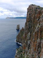

Cape Pillar from the end of Cape Hauy - 11th August 2008Once you descend onto the peninsula of Cape Hauy, the views to north and south open up quite dramatically. To the south, Cape Pillar makes a fine sight, with The Blade and Tasman Island visible. To the north, the coastline of the Tasman and Forestier Peninsulas, Cape Bernier, Maria Island and Freycinet are visible. On a clear day you may be able to see further than that. The track emerges at the end onto a small rock platform with a sheer 100m+ drop into the sea. Great care is required (especially if here with children), but this is the best spot for stopping and taking in the views and having lunch. Cape Hauy is home to the Candlestick and Totem Pole, both of great interest to climbers. They make spectacular viewing.


The Candlestick from the end of Cape Hauy - 11th August 2008The Candlestick stands next to the end of the Cape clearly visible just next to the lunch spot, and behind it are The Lanterns. The Candlestick is a very tall and thin sea stack, separated from the Cape and the Lanterns by the sea. Lots of information here about climbing these things. As their guide says, the crux of the climb up the Candlestick is the SWIM! You can scramble down the less steep side of the Cape towards the sea, and actually you can get within a few metres of the sea if you keep going. This requires great care in places, and of course you have to climb back up the 100m of height. It does however afford better views of the Candlestick and Totem Pole, and these start only a short way down. My perambulations yesterday had to be curtailed because I took a sidetrip to the Tesselated Pavement on the drive in and left myself rather short of time.


The top of the Totem Pole from Cape Hauy - 11th August 2008Next to the Candlestick stands the Totem Pole. The climbing guide says this about the Totem Pole: "It is over sixty metres tall, but only about four metres wide at the base. It sways in the wind and shudders with the crash of every wave." Go here for some more dramatic photos of the Totem Pole.


Cape Pillar from the Monument Lookout - 11th August 2008A final detour on the return is well worthwhile to the Monument Lookout. This stands on top of a vertical 150m drop to the sea, and requires great care, as the rocks are rounded and sloping, with good sized cracks between them. Views from here are to the rock stacks off Cape Hauy and Cape Pillar, and in fact very dramatically straight downwards to the surface of the sea. Great place to sit on a nice day.


View Larger Map

Thursday, 7 August 2008

Big job ahead for the Huon Valley Council

Erica lusitanica, Spanish Heath, Arve Rd, Southern Tasmania - 17th July 2008Now that I know what I'm looking for I can see that the Erica lusitanica infestation on the Arve Road actually extends for about half a kilometre along the roadside. I think this would be quite a job to remove, and I suspect it won't get a look-in, being a "low-priority" weed.

New view from the Hartz Mountains

Newood timber processing site visible from Hartz Peak - 4th August 2008I know we have to process the wood we harvest as much as possible before we export it, but do we have to build factories to do it where they can be seen from the most accessible summit in the World Heritage Area? We try to encourage tourists to come here, then we stick a new factory on the edge of the WHA where its buildings and especially its smoke emissions are visible from the Hartz Mountains. Bonus! This is Newood, formerly Southwood (note the url, they changed the name because of the original bad publicity. The website seems to be a little out of date), built near the Huon River to process timber from the nearby forests in various ways. It's supposed to have a wood-burning power plant eventually, I bet that'll make it even more attractive. As it is, it stands out very clearly against the backdrop of forests.