


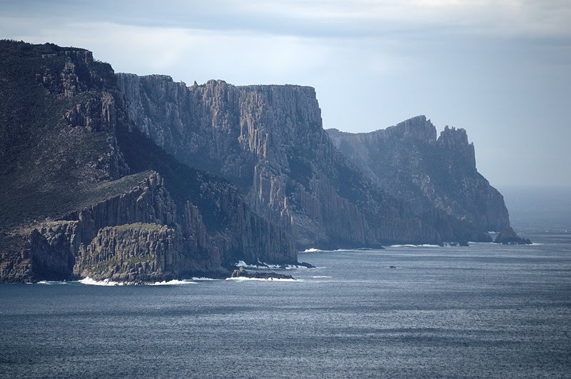
 I haven't done this walk for about 20 years. It's normally labelled as Canoe Bay and Bivouac Bay, which are passed along the way, but the aim should be to walk on beyond Bivouac Bay and up onto the cliffs just north of Dolomieu Point, which give grandstand views of the rocks at Thumbs Point and Cape Hauy.
 The walk starts at the Fortescue Bay carpark, and heads north along the beach. The creek flowing from Fortescue Lagoon has been flowing strongly with recent rain, and may need to be waded. (On the return it was nearly narrow enough to jump given the lower tide.) At the north end of the beach, the track climbs a little into the forest. The walking is easy and pleasant, and the track meanders through the forest for a while before descending to Canoe Bay. Here a sunken steel boat now serves as a large perch for cormorants, but is said to have been a breakwater for fish processing works which formerly operated here. A very rough 4WD track (Canoe Bay Track on the 1:25,000 map) intersects the walking track just before it arrives at Canoe Bay. This track apparently heads off uphill and joins Fortescue Road.
 The track continues beyond Canoe Bay, crossing the substantial creek on a good suspension bridge, and contouring around the north side of Canoe Bay. The track then climbs about 110m quite steeply over the headland and descending again to Bivouac Bay. Here there is a toilet and camping area, with water available from the creek - apparently permanent.
 The track then continues around the head of the bay across the creek, and climbs 100m to cross Dolomieu Point and emerge on the cliffs just north of the point. There are several good lunch spots within a few minutes of the top of the hill where you can sit on flat rock at the edge of the cliff with spectacular views. This climb at the end is very well worth it.


 To round out the Tasman Peninsula weekend, I did Mount Brown and then walked on to Cresecent Bay. See previous exploits, which include a map. The cliff on the south-western side of Mount Brown remains a "high"light. The shape of the top of the cliff means people like me with borderline height-tolerance can securely sit with a leg, or even two, dangling over this 170+m cliff without feeling insecure. It gives a great vertical view to the sea, and back towards Remarkable Cave across Dauntless Point. Mind you, this is where I misplaced Phil for a few slightly concerning minutes on a walk a while back. The photo here is of Cape Pillar from the Mount Brown trig, with The Blade in clear view protruding at the right. Mount Brown affords great views of both Cape Pillar and Cape Raoul, along with their related topography, as well as of the whole of Port Arthur.
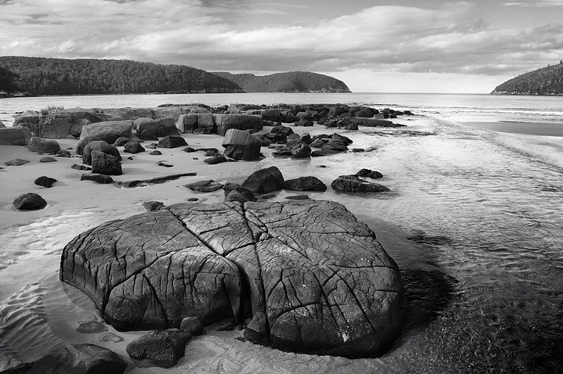
 Crescent Bay is superb, although not necessarily a nice safe swimming beach. The waves break beautifully at times, but the beach falls away quite steeply. Looks good for fishing. In the middle of the beach is this rocky outcrop, with a big dune that drops steeply behind it. The rocky outcrop looked to me like a metamorphosed mudstone or similar, which shows the obvious signs of salt water weathering. It's really quite interesting. David Leaman confirms in "Step into History in Tasmanian Reserves" some of my inexpert assessment, but adds a lot more information.
 This is Mount Brown as seen from the northern end of Crescent Bay. The cliff is on the far side. Crescent Bay's most notable feature is its tall dunes. There were people sliding down the dune in the middle of the beach on sandboards and other items. I'll do a blog about sand dunes sometime soon, but they didn't seem concerned about their use of the dune in this way. Other people do the same down the dunes at the northern end at times too. I don't know really, but I do know the dunes at Crescent Bay have been there for 20 years, and don't seem to have diminished. Perhaps the wind restores them. I see there are some track notes for this walk here.
 Had a trip down to the Tasman Peninsula and took the opportunity to wander out to Cape Hauy on Day One. This is a good walk, and I've put it up on here before (here and here). The starting point is Fortescue Bay, and the track is easy to follow. The walk undulates quite a lot, and although no individual hill is more than medium-sized it's a good bit of exercise after you've climbed and descended a few times. Views are great and the cliffs spectacular, although the light was a bit flat the other day for photography.
 The sidetrack to the Monument Lookout (on the way to Mount Fortescue) is well worth the short diversion, and provides a very airy view of the bay stretching south to Cape Pillar. Note that there are many opportunities for falling off cliffs along this track, so younger members of the party should be supervised appropriately. In particular, the flat spot at the end of the walk is basically surrounded on three sides by 120m cliffs sheer to the sea, which makes a great place for lunch but not for wandering about carelessly. The Candlestick and Totem Pole, both goals for climbers, are located at Cape Hauy, and while they are visible from the top of the Cape, better views are available by descending steeply (and very carefully) to the northeast along obvious pads and tracks along the edge of the cliffs towards the sea.
 Cape Hauy, the Lanterns, the Candlestick and the Totem Pole are all visible from the lookout above Pirates Bay. This is reached by turning left along the old highway before commencing the steep descent on the new highway towards Eaglehawk Neck. The views across the bay are worth the diversion.

