Monday, 25 February 2008

Book Review: Van Diemen’s Land by James Boyce

John Glover's Mount Wellington and Hobart Town from Kangaroo Point, at the TMAG website

As someone who enjoys the Tasmanian bush, particularly its accessibility, cleanness, and wildness, the concept of Tasmania as being different and comparatively special is important. On most measures I just think the rest of Australia can’t compare, but the things which make our state special are sometimes not obvious, even to those who live here, and they are so easy to destroy or degrade. Here we have a history book which actually makes some interesting observations about how we might relate to our situation today.

This is a very interesting book, in which James Boyce throws new light on the early white settlement of Tasmania. He makes the distinction between “Van Diemen’s Land” and “Tasmania” very clearly. He says in the introduction that his hypothesis is “the character of the island which became the enforced home of over 72,000 sentenced criminals (42 percent of the convicts transported to Australia) does matter. The fact that protein-rich shellfish were there for the taking , that wallaby and kangaroo could be killed with nothing more than a hunting dog, and that abundant fresh water and a mild climate made travel by foot relatively easy, does change the story. The convict’s hell was, thank God, a human creation alone. This book is about the tension produced by siting the principal gaol of the empire in what proved to be a remarkably benevolent land. It sees this paradox to be at the heart of early Tasmanian history, and to have important implications for the nation as a whole.”

Boyce shows how early Tasmania was quite unlike early New South Wales. He points out that the Van Diemen's Land settlers were probably the healthiest people in the British Empire, and this arose from the nature of the land they had settled. Life in early Van Diemen's Land was, while not always idyllic, quite unlike the way we imagine it from our understanding of later history – for example, under Governor Arthur, or as portrayed by Marcus Clarke in For The Term Of His Natural Life. Eventually the authorities realised that the life of the convicts transported to Van Diemen's Land appeared to be better than that which they left behind. It didn’t seem to be a punishment at all.

The view of Tasmania as cold, wet, poor, backward and unimportant continues today. When you read Saul Eslake’s assessment (Talk transcript here) of Tasmania from the point of view of his economic and social data, it can seem a little bleak, although much improved from the deep dark days of the Gray administration. I sat in a room where Saul’s view was presented to a senior manager from Canberra. She took it all in, understanding the implications of some of the negatives for particular segments of the population, but at the end waved her hand out the window at the tremendous view of blue sky and fluffy white clouds behind a sunlit Mount Wellington, speechlessly implying “well yes, some of those things aren’t great, but look where you live!!”

Our value as a state, a people, as communities, is not measured by our wealth, our sophistication, our adoption of new technology and the ways of the “mainland”. Tasmania really is a little different, and Boyce suggests some of the ways this difference developed and perhaps remains.

It just isn’t quite the way it’s seen. We have our problems, but we also have the compensations that come from living in one of the most beautiful places on earth. The original Eden was brought undone, often in evil, corrupt and incompetent ways. How true that is of today.

Dead trees south of Oatlands - 19th February 2008

The violence towards the aboriginals, and the poor whites, is all in this book. Boyce makes the interesting suggestion that one of our major environmental problems was caused by our racism. He offers the opinion that the reason the trees no longer grow properly in much of the southern midlands is the possum population, a population that was kept in check by the aboriginals. Once they were gone, our trees had no hope.

I really enjoyed this book. It’s easy to read, interesting and challenges us to see Tasmania in a different light.

Here's a link to an extract.

Here's Richard Flanagan's review of the book in the SMH.

Henry Reynolds' review is here.

Published by Black Inc. Books (www.blackincbooks.com) Melbourne 2008

Haughton Forrest and Mt Wellington

This beautiful view of Mt Wellington behind Hobart, painted by Haughton Forrest in 1886, hangs in the Tasmanian Museum and Art Gallery. I especially like his rendering of the snow in the gullies above where the Zigzag Track now runs. It's worth a visit to see for yourself. The original is 86.7 x 183 cm and is very impressive.

Saturday, 23 February 2008

McDermott's Farm - Pipeline Track

Mt Wellington from near the site of McDermott's FarmFrom the sign at the site of McDermott's Farm on the Pipeline Track.

For all its continuing natural appeal, Mount Wellington has many reminders of the impact of settlement. Around this point is much evidence of such impacts, including land clearing, building construction, the effects of fire and the channelling of water for human need. Studies point to significant use of the Mountain foothills by Palawa, Mouheneenner and other peoples of pre-European times. The Palawas helped to create the open grasslands of the Chimney-Pot Hill area through regular burning of forests to assist them in hunting game. There is evidence of seasonal occupation: rock shelters in sandstone outcrops and pieces of flaked stone on the banks of Sandy Bay Rivulet north of here.

This open area, occupied by the McDermott family from the late 1880s, was one of many private holdings in the Mount Wellington foothills at that time. Behind you on the opposite hillside is Turnip Fields, a subdivision of another of the early private mountain landholdings. Under the track about 50 metres below here you can see a stone culvert made in the early 1860s for the original water supply line. There are several more of these between here and Halls Saddle.

Bill McDermott ran a farm on this property for many decades. A unmarried recluse, his only companion a dog called Brandy Shamrock McShane. Bill left his property once a week to buy groceries in town. Bill allowed his cattle to graze on the adjacent Ridgeway Reserve, leading to a long-running dispute with the Hobart City Council. On 7th February 1967 the Black Tuesday bushfires destroyed most of the farm, but 80-year-old Bill managed to save his home and his six cattle. He planned to rebuild, but only 10 days after the fire he was gored to death by one of his fire-traumatised bulls. The location of his homw, demolished by the Council, is marked each spring by blooming daffodils.


From Hobart City Council sign: The Pipeline Interpretation Project. An initiative of the Fern Tree Community Association, supported by the Hobart City Council. Original research by Lindy Scripps.

Halls Saddle - Pipeline Track

The Pipeline Track crosses Chimney Pot Hill Road, right next to the Huon Road - 23rd February 2008From the sign at Halls Saddle on the Pipeline Track.

Welcome to the Halls Saddle entrance to the Pipeline Track, an easy walking trail that follows the historic Pipeline to its source at the North-West Bay River.
Before the Europeans came to Tasmania in 1803-04, these mountain foothills were visited by Palawa people. They came here hunting game, but never travelled far from natural water sources. These two factors – food and water – determined the seasonal travel patterns of the Palawa.

Settlers were more demanding. As soon as they landed on western Derwent shores they had to think about a water supply for a growing community. An early supply from Hobart Rivulet was limited by the size of the rivulet and by property owners exercising prior rights. In 1860 the Hobart Town Corporation decided to tap the water from Mt Wellington’s southeastern slopes. This saddle joining the lower slopes of Mt Wellington and Chimney Pot Hill, to the east, is named after John Hall, an original landowner in the Fern Tree area who built the first Fern Tree Inn in 1861.

Halls Saddle was a key point in Hobart’s Mountain supply system. Water from streams flowing southeast had to be diverted across this saddle to reach the Sandy Bay Rivulat reservoirs at Waterworks Reserve, from which the city could obtain its water. From about 1940, virtually all water from mountain streams above the Pipeline Track was diverted near this point to the higher-level Ridgeway reservoir. Drinking water collected from Mount Wellington is still fed to the community through pipes that are directly under the walking track ahead.

The original road between Hobart and the Huon Valley wound up the Sandy Bay Rivulet to the north of here and across this sadlle. It is the route most likely used by Charles Darwin in his ascent of the mountain when he visited Hobart Town in 1836. He later complained that his guide had led him up the wetter, more difficult southern side of the mountain.

“Timber built, bark roof, stone chimney, two storeys with upper and lower verandahs likened to Hobart’s old double-decker trams.” Situated north from here on the Sandy Bay Rivulat, Fern Grove Hut was the only privately-built two-story timber hut near the Pipeline Track. Many huts were privately built on the mountain during the 1800s, but only one has survived; Lone Cabin near the Lenah Valley Track.


From Hobart City Council sign: The Pipeline Interpretation Project. An initiative of the Fern Tree Community Association, supported by the Hobart City Council. Original research by Lindy Scripps.

Gentle Annie Falls - Pipeline Track

Wtare channel carved from the rock (dolerite) at Gentle Annie Falls, Waterworks Reserve, Hobart, Tasmania - 16th February 2008From the sign below Gentle Annie Falls at the Waterworks Reserve.

Before the Europeans came to Tasmania in 1803-04, these mountain foothills were visited by Palawa people. They came here hunting game, but never travelled far from natural water sources. These two factors – food and water – determined the seasonal travel patterns of the Palawa.

Settlers were more demanding. As soon as they landed on western Derwent shores they had to think about a water supply for a growing community. An early supply from Hobart Rivulet was limited by the size of the rivulet and by property owners exercising prior rights. In 1860 the Hobart Town Corporation decided to tap the water from Mt Wellington’s southeastern slopes. As you walk the Pipeline Track you can see evidence of changing construction techniques along the Pipeline Track with improving water management technologies. The first stages of construction (1861) used wooden and masonry troughing. Extensions and redevelopment use earthenware pipes (1873), cast iron pipes (1901) and steel and concrete pipes (from 1917).

If you look up at the stone outcrop you can see a channel cut into the natural sandstone, where water from the mountain cascaded down to the Upper Reservoir at Waterworks Reserve. The cascade soon became known as Gentle Annie Falls (possibly after “Gentle Annie” in the Irish folk song), a name which it has kept even [though] it has been dry since about 1940 when its water was re-directed to the higher-level Ridgeway Reservoir.

Part of the water channel and works below Gentle Annie Falls, Waterworks Reserve, Hobart, Yasmania - 16th February 2008The local sandstone was also used for other pipeline works, including the stone aqueducts built at Fern Tree in 1881.To the right of the channel you can see a quarry from where building stone was cut.


From Hobart City Council sign: The Pipeline Interpretation Project. An initiative of the Fern Tree Community Association, supported by the Hobart City Council. Original research by Lindy Scripps.

Tuesday, 19 February 2008

Woodchip-pile-cam - 18th and 19th Feb 2008

Burnie woodchip pile, truck unloading, bulldozers behind on the pile - 18th February 2008Our forests continue to go overseas from Burnie, including whole logs. Now if Gunns manage to "replace" woodchip exports with pulp production in the Tamar Valley, how many of these woodchips will travel to Bell Bay rather than getting exported from here? Careful, it's a trick question.


Saul Eslake says in various places and forums:


Burnie woodchip pile and unprocessed logs on Burnie wharf - 19th February 2008"Tasmania's future cannot possibly lie predominantly in the volume production of essentially unprocessed commodities at lower prices than competitors with better access to; larger and cheaper resources of labour and capital, and to markets (by virtue of proximity of membership of trade blocs). But, instead depends on its capacity to produce and market highly differentiated goods and services, embodying a relatively high intellectual content, for which customers are willing to pay premium prices."


Read the Worrying Conjunction post to get some more background.

Burnie woodchip pile steaming (or smoking?) - 19th February 2008The operation at Burnie goes day and night. I noticed the woodchip pile either steaming or smoking. Must be hot in there. Maybe the two bulldozers were trying to uncover the hotspot? Wouldn't be a good look for it all to go up in smoke.

Monday, 18 February 2008

EucaFlip - "Book" Review

Detail of cover, EucaFlip, Copyright Rob Wiltshire 2007I found this marvellous little identikit for Tasmanian eucalypts, called EucaFlip. It's by Rob Wiltshire and Brad Potts, and is a "Life-size guide to the eucalypts of Tasmania". I was taken by the thought of a "life-sized" guide including the Eucalyptus regnans, so I bought it on impulse. Crikey!! It's only the leaves and fruits that are "life-size". I was dudded! No seriously, this little fold-out is great. It's small and lightweight, and folds out like a map. It seems to have all the Tasmanian eucalypts. (I'm not exactly the utlimate expert, although I do know those eucalypts confuse us by producing naughty mixed species, intermediate between some of the main ones.) It's also covered in plastic and is quite stiff, so it looks like it'll tolerate my usual "care" when out walking. The pictures are great, very clear, and life-size. No guessing: "that picture looks like about 3/4 of the size of that gumnut!". It has a short key based on the number of buds per umbel. Each species guide has life-size pictures of the leaves, both juvenile and adult, plus the buds and capsules. Some include the flowers. For each species there is also a small distribution map and a picture of the bark. All are in vivid colour. The overall impression is very attractive (can I just say my photo of part of the cover doesn't do it justice, it's very well produced, lush and glossy). I got it at Angus and Robertson in Burnie, but I assume it's available lots of places. It was $10 there. Incidentally, A&R in Burnie have a good Tasmaniana section, better than their Hobart shop, and better than Fullers. This guide is published by the School of Plant Science, University of Tasmania, and CRC for Forestry.

Monday, 11 February 2008

Hartz Peak - 11th February 2008

Mountain Rocket flower (Bellendena montana), Hartz Mountains - 11th February 2008Yes, sadly, another Hartz Peak climb (Map here). I had hoped for a nice sunrise morning on the plateau, perhaps with a quick clamber to the summit to see the view. Mmmm. What sunrise? What view? Shouldn't complain. The cloud was restful, the drizzle was light (if horizontal), and the wind wasn't as strong as it could have been. So, no view, no sunrise to photograph, and the wind made it very difficult to get nice close-ups of some of the attractive plants. There was only one thing for it; climb to the top. Actually, I did enjoy being on my own on this long weekend. This was an early-ish walk, setting out at 7am. One of the ladies heading up the hill as I arrived back at the start assumed I had abandoned the attempt. I think I was a little obscure in my response. The sign says it's a 4 hour walk, and used to say 5 hours, so maybe that's a reasonable assumption at 10am.

Mountain Rocket fruits (Bellendena montana), Hartz Mountains - 11th February 2008The Mountain Rocket (Bellendena montana) is just turning from its flower phase (above, and earlier, properly in flower) to its fruit phase (right). The fruit takes over from the flowers, and is very distinctive, flattened and hanging down, the resulting shape giving rise to the common name.


Mountain Pepper, Tasmannia lanceolata, Hartz Mountains - 11th February 2008Actually I was taken by the appearance of the leaves on this plant, especially with the water droplets. I'm pretty sure it's the Mountain Pepper (Tasmannia lanceolata). The fruits, and I think the dried leaves as well, are now used as premium food seasonings. To quote from "Wildflowers of Tasmania" (King and Burns, 1986) "Tradition has it that the berries were used by early settlers as a substitute for pepper, and the practice still persists in feeding the leaves to unsuspecting strangers under the pretence that they are delicious." Who knows!


Lomatia polymorpha, Hartz Mountains - 11th February 2008Now this one took me a while, but I think it's Lomatia polymorpha. I'm sure it's a Lomatia, but picking between the various pictures of L. polymorpha and L. tinctoria was a bit tricky. Apparently it's widespread on mountains and flowers in January. Check! The leaves also vary in shape to trick amateur botanists.


Dwarf Leatherwood, Eucryphia milliganii, Hartz Mountains - 11th February 2008I think this last one is the Dwarf Leatherwood, Eucryphia milliganii. Interesting historical fact: "The name 'leatherwood' was originally given to Acradenia franklinii, possibly on account of the toughness of its wood, but by 1903 was being transferred to the Eucryphias, which produce honey". (King & Burns, 1986)

Sunday, 3 February 2008

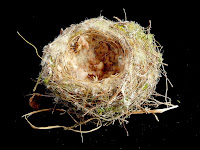
Bird's Nest

Bird's nest - 3rd February 2008Now, this is from the garden, but I suspect the bird that made it also inhabits the nearby bush. The kids found this in the garden the other day, fallen from a tree. We were amazed at the affort some small bird had gone to in making it. Uncertain about what sort of bird would have made this, but we have quite a variety of small birds here, despite the cat!


Side of bird's nest - 3rd February 2008The intricacy of the "basket-work" is very impressive, as is the range of materials they collect and work into the structure. The moss included in this one adds a certain decor to the whole thing.


Inside of bird's nest, showing use of wool base - 3rd February 2008Most interesting is the way the bird has incorporated what appears to be tufts of wool into the base of the nest, making a very cosy bed for a newly hatched chick. It's not clear whether it's found the wool on a sheep or from a manufactured item. It does go to show you one more way in which wild animals incorporate the man-made environment into their world. I imagine this is quite useful, keeps the chick warm and comfortable...

A worrying conjunction

Clearfelled hillside, Southern ForestsSeveral reports recently suggest Tasmania faces a bleak future:

The Mercury reported on 31 January that Access Economics' investment forecast for Tasmania shows we are reliant on large projects.:


Tasmanian Times reported that a respected economist (in a report completed at the behest of the Wilderness Society) has suggested the median likely result of building the pulp mill will be a $300 million dollar loss for Tasmania. This doesn't include the impenetrable web of govenrment subsidies propping up the whole forest industry, because he assumes these will continue whether or not the mill goes ahead.


Meanwhile The Australian reports that the Australian Government view is that "TASMANIA'S forest industry faces a bleak outlook", in a report prepared for the federal Department of Agriculture, Fisheries and Forestry, and only released publicly after an FOI request.


Just to remind you, as we go back in time, Naomi Edwards wrote a clear warning about this to the RPDC and anyone else who would listen. Of course the government did a quick and dirty assessment of the benefits of the pulpmill, ignoring the costs and risks, thus demonstrating appalling mis-management of Tasmania and its future. Sure, the pulpmill might be of benefit to the shareholders of Gunns (although it appears the ANZ are still considering that), and maybe to a small number of remaining forestry employees. The overall value to Tasmania has to be seriously in doubt. Don't expect any coherent rebuttal of these reports from the government.


Maybe it's time for us to go back and look at some other options for Tasmania's future. They can't be any worse can they. The Greens Forest Transition Strategy (brief version here, Greens' forest site here) might be worth a look.

South East Cape

South East Cape from South Cape Bay cliffs - 6 October 2007I realised that I don't have a very clear picture of South East Cape up here, despite having eleventy-seven instances of walks to South Cape Bay. Here's a clear view on a sunny day of South East Cape from the cliffs at the eastern end of South Cape Bay. South East Cape is the southernmost point of mainland Tasmania. It is apparently accessible via an illegally-cut track which requires some tide-dependent sea-level traversing to the east. I might go and try to find it one day.