


This large sea-stack is just off to the south of Cape Hauy (clearly visible from the track) was first climbed in 1970 by a Climbers' Club of Tasmania group. This sea-stack is much less popular than the others in the area, perhaps due to the fact that it is not as dramatic looking and is only about 50m high. However, since it is about 100m off shore, it is not any less of an mission to reach the top. Indeed, the tale of the first ascent is yet another grand CCT epic spread over a few attempts.
Prior to the successful attempt, Mendelt Tillema had already swam out to the stack, though his companion (Peter McHugh), who planned to follow in a rubber dingy was not able to make it out to the stack due to the swell. Mendelt swam back to shore and the attempt was aborted. The next time, Mendelt again swam (trailing a rope) to the prominent ledge on the NE corner of the stack. Mike Emery and Ray Lassman tied in the middle of the rope and followed, while Col Hocking held the other end and waited on the mainland should things get messy. McHugh contributed to proceedings by tumbling down the cliff as the start of the day, leaving blood stained rocks as markers for the path to the sea.
From the ledge, the team took the prominent chimney in the corner. This was an 80ft (or 25m) pitch at a grade of "VDiff" (now considered about grade 12-ish), and then a scramble to the top. Upon erecting a cairn they donated some green tights for a flag, though it appears these have long since blown away.


 Cliffs at Fossil Cove.
 Had a nice walk to South Cape Bay. This fellow was happily munching ants along the track and was quite unconcerned about me, at least until the camera's flash became annoying.
 Lots of interesting flotsam on the beach, including this sponge.
 Stormy weather had washed up large mounds of kelp, which makes for interesting foregrounds in photos at least.
 I wondered about harvesting some pieces to see if I could make some of those lovely water-carriers and other items the Aboriginal ladies make. Then of course I remembered it's a national park...
 There were quite a lot of dead shearwaters around. I've also seen significant numbers on Fortescue Bay Beach.
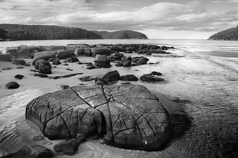
 Stormy weather had altered the beach quite a lot. There was lots of exposed rock and sand had been stripped from most parts of the beach.
 The Tasmanian Laurels (Anopterus glandulosus) were in flower along the track, noticeably in the old sand dunes behind the beach.
 This walk connects Hartz Peak and Mount Snowy south of the main peak, with some off-track and route walking. It provides great views while traversing along the ridge. Emily and Arthur Tarns are features of the return walk. The walk starts with a standard ascent of Hartz Peak. It is advisable to carry extra water, as you are unlikely to find any until descending to Emily Tarn after the ascent of Mount Snowy.
 The route then heads along the ridge to the south. The first part of the ridge consists of buttresses, and you need to descend to the right/west to boulder-hop around their lower ends. If tempted to climb back to the ridgeline, you'll get a good view and there are some good cliffs to look down, but you need to get past a good few buttresses before the ridge-top is easily navigated. There is no need to do any rockclimbing or even actual scrambling at any point going in either direction. If you find that you need to, you've missed the easiest way and can either proceed if comfortable, or go back a bit and find an easier way. Eventually the ridge starts to drop steeply towards the Hartz/Snowy saddle. There is a little scrub here and you may have to wade through some scoparia, but it's pretty easy to tell where you're going. Descend to the saddle. Note that from this point you can walk along the south ridge to Adamsons Peak. I gather it's a bit dry and scrubby, and it would be best to get some directions from someone who knows the best way.
 From the saddle there is a cairned route up Mount Snowy. It's occasionally indistinct, but basically head for the big scree patch and there are cairns up the middle of it. You'll know when you're at the top - it's the highest bit.... Good views of Hartz Peak from here, as well as the ranges to the south. Descend again to the saddle.
 From the saddle there's a cairned route which drops off to the right/north and heads for Emily Tarn. This passes through alpine shrubberies which can be a little moist underfoot at times. The way is also occasionally indistinct. In clear weather you can see Emily Tarn though. (Maybe when it's foggy, people who haven't done this walk before might be advised to leave it for another day actually.) Emily Tarn is lovely, with the cliffs and crags of Hartz Peak ringed above it, and with a great view of Mount Snowy. There are good spots to put up a tent here, but please don't take lots of people there, it's pretty fragile. Oh, and there aren't LOTS of tent sites, certainly not together.
 The return track continues around the right of the tarn and then climbs to a cushion-plant lawn in a tiny saddle between Emily and Arthur Tarns. This bit is definitely moist underfoot, and is becoming a little degraded. The track descends slightly to Arthur Tarn which sits perched above a steep drop and can be very visually attractive. Below Arthur Tarn the track drops down the outlet creek, and winds down a little before entering the creek bed which it follows for a couple of hundred metres. You need some navigational smarts below here, keeping a lookout for cairns and tags. The track then undulates across the plateau to return to Ladies Tarn. As a useful guide in clag, it would be a good idea to have marked Ladies Tarn in your GPS to give you something to aim at. The track has some apparent false leads in a couple of places. If the track peters out, backtrack a little and cast about for another route. This plateau walk can be wet to very wet underfoot, and will boots will probably be most comfortable. The track emerges just above Ladies Tarn, and you turn right to retrace the walk to its beginning.


Kerosene Bush, Ozothamnus ledifolius - Photo here also.


 Walking to Dauntless Point involves climbing to about the 100m level up the normal Mount Brown track (I went a bit higher actually) and then sidling back on steep sloping rock, boulders and scrub to the northwest and then west. There's a sort of saddle between Mount Brown and Dauntless Point, which drops very steeply (and dangerously, with loose pebbles and gravel) into a gulch to the south. I think Dauntless Point could be approached from the north directly, but there's a fair bit of woody scrub, and there may or may not be a clear path. Sidling round Mount Brown wasn't too hard. From the saddle, you climb easily onto the highest point and then beyond, with occasional pushes through bits of scrub, and a couple of points where the track is very close to the impressive cliff. With the wind blowing it was interesting, but not too problematic. I think those who don't like heights would have problems, as the cliff falls away in a clearly visible slope from several spots. The views of the cliff on Mount Brown are superb. There comes a point where the scrub thickens and the slope steepens significantly, and I didn't go all the way out to the end of the point. Maybe next time.
 This cliff on Mount Brown's southwestern side is about 170m tall. The picture above doesn't really do it justice, but a tall person would be 1/85th of the height of the cliff. You can stand on the highest point visible in this picture, and would be visible in a picture like this,but very tiny. The cliff appears to slope outwards from that highest point, but is then basically massively undercut. There is a big sea cave at the base of the cliff, and the whole cliff sweeps inwards to it. The (guessed) 4m swells were making a good show as they rushed inwards. The dynamics of the water rebounding from the cave suggested that it is reasonably deep. Mount Brown must one day collapse at this point - and indeed to cut the cliff as it is already there must have been significant collapses in the past. Anyway, the view is pretty impressive.
Note: there is no marked track to Dauntless Point, there are no safety features or warning signs, and the whole area has numerous huge cliffs which would be fatal if toppled off. Use this area at your own risk. Keep children close.
 I went back to Cape Hauy in better weather, and among other things clambered down at the end of the cape a fair way. This provides a good view of the Candlestick, showing the size of it very clearly.
The forest was full of flowers, very pretty.


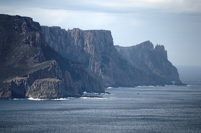
 I haven't done this walk for about 20 years. It's normally labelled as Canoe Bay and Bivouac Bay, which are passed along the way, but the aim should be to walk on beyond Bivouac Bay and up onto the cliffs just north of Dolomieu Point, which give grandstand views of the rocks at Thumbs Point and Cape Hauy.
 The walk starts at the Fortescue Bay carpark, and heads north along the beach. The creek flowing from Fortescue Lagoon has been flowing strongly with recent rain, and may need to be waded. (On the return it was nearly narrow enough to jump given the lower tide.) At the north end of the beach, the track climbs a little into the forest. The walking is easy and pleasant, and the track meanders through the forest for a while before descending to Canoe Bay. Here a sunken steel boat now serves as a large perch for cormorants, but is said to have been a breakwater for fish processing works which formerly operated here. A very rough 4WD track (Canoe Bay Track on the 1:25,000 map) intersects the walking track just before it arrives at Canoe Bay. This track apparently heads off uphill and joins Fortescue Road.
 The track continues beyond Canoe Bay, crossing the substantial creek on a good suspension bridge, and contouring around the north side of Canoe Bay. The track then climbs about 110m quite steeply over the headland and descending again to Bivouac Bay. Here there is a toilet and camping area, with water available from the creek - apparently permanent.
 The track then continues around the head of the bay across the creek, and climbs 100m to cross Dolomieu Point and emerge on the cliffs just north of the point. There are several good lunch spots within a few minutes of the top of the hill where you can sit on flat rock at the edge of the cliff with spectacular views. This climb at the end is very well worth it.


 To round out the Tasman Peninsula weekend, I did Mount Brown and then walked on to Cresecent Bay. See previous exploits, which include a map. The cliff on the south-western side of Mount Brown remains a "high"light. The shape of the top of the cliff means people like me with borderline height-tolerance can securely sit with a leg, or even two, dangling over this 170+m cliff without feeling insecure. It gives a great vertical view to the sea, and back towards Remarkable Cave across Dauntless Point. Mind you, this is where I misplaced Phil for a few slightly concerning minutes on a walk a while back. The photo here is of Cape Pillar from the Mount Brown trig, with The Blade in clear view protruding at the right. Mount Brown affords great views of both Cape Pillar and Cape Raoul, along with their related topography, as well as of the whole of Port Arthur.
 Crescent Bay is superb, although not necessarily a nice safe swimming beach. The waves break beautifully at times, but the beach falls away quite steeply. Looks good for fishing. In the middle of the beach is this rocky outcrop, with a big dune that drops steeply behind it. The rocky outcrop looked to me like a metamorphosed mudstone or similar, which shows the obvious signs of salt water weathering. It's really quite interesting. David Leaman confirms in "Step into History in Tasmanian Reserves" some of my inexpert assessment, but adds a lot more information.
 This is Mount Brown as seen from the northern end of Crescent Bay. The cliff is on the far side. Crescent Bay's most notable feature is its tall dunes. There were people sliding down the dune in the middle of the beach on sandboards and other items. I'll do a blog about sand dunes sometime soon, but they didn't seem concerned about their use of the dune in this way. Other people do the same down the dunes at the northern end at times too. I don't know really, but I do know the dunes at Crescent Bay have been there for 20 years, and don't seem to have diminished. Perhaps the wind restores them. I see there are some track notes for this walk here.


